
What do we do?
We strengthen corporate value and trust through the diagnosis and prediction of critical scenarios with operational, environmental and regulatory impact.
We increase resilience, excellence and competitiveness through advanced geospatial analysis and historical comparative evaluation.
We anticipate critical risks and propose their mitigation through early detection of physical anomalies and trends.
We improve operating costs and return on assets through technical prioritization based on verifiable evidence.
We ensure environmental and regulatory compliance through traceable, comparable and defensible reports.

Why VORENTIS™?
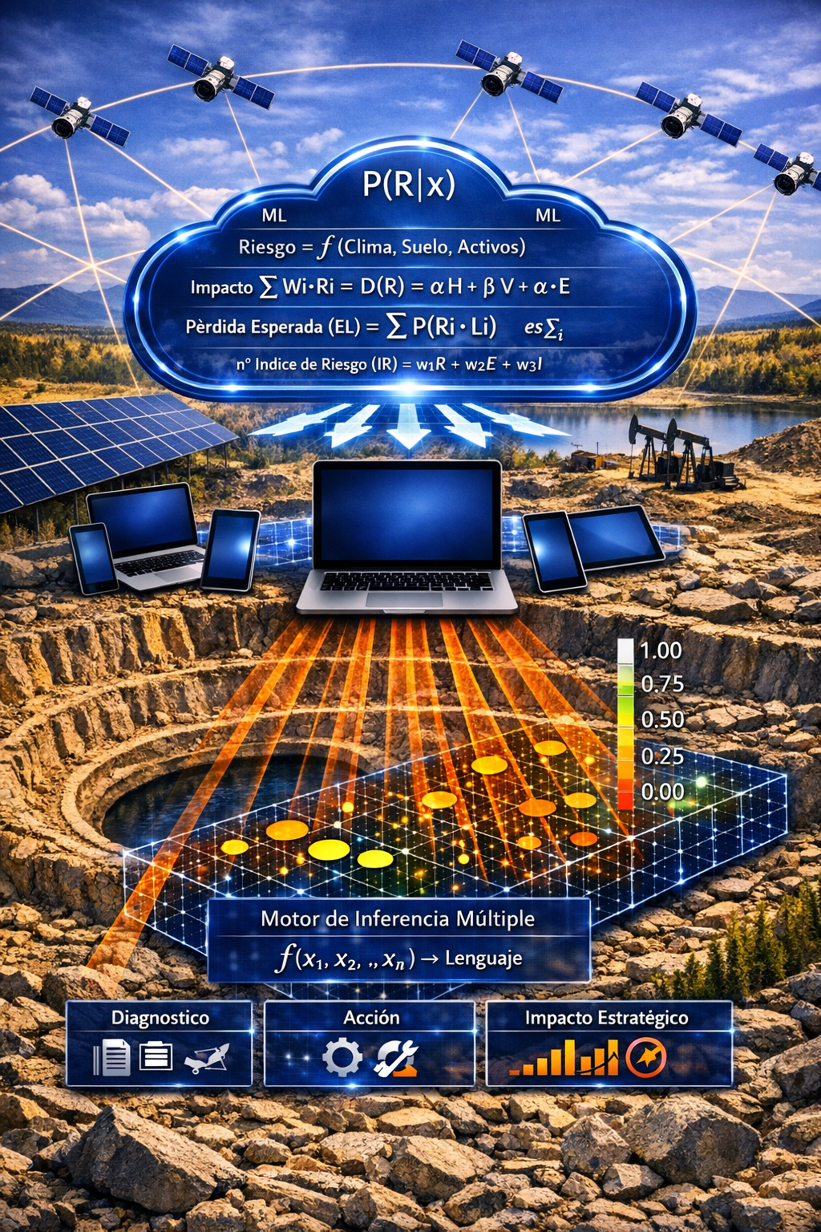
VORENTIS is an alternative to the traditional reactive and fragmented solution.
It delivers an online, timely and predictive diagnosis of geospatial intelligence, applied not only to specific zones but also to the entire asset within its operational and environmental context, avoiding environmental and regulatory impacts, contributing to operational continuity and strengthening reputation.
This, at portfolio scale and backed by auditable scientific support.
Traditional Solution (Without VORENTIS™)
Executed by experts, based on the analysis of data obtained from sensors, satellite imagery, drones, and periodic technical field inspections.
Diagnostics with limited frequency, latency of weeks, extensive and highly technical language, divergent among experts, without predictive capability, focused only on areas of concern, and without an integrated view of the operational and environmental context.
It does not prevent environmental and regulatory impacts, fines, sanctions and legal contingencies, shutdown of critical assets, and reputational deterioration.
Unique Attributes
¡We don’t replace consultants — we anticipate them!
V — Velocity of diagnostic insight
Diagnoses and predicts in seconds, long before traditional expert reports deliver solutions.
O — Operational continuity in the cloud
Operates as a 24/7 SaaS infrastructure across multiple assets and clients, independent of field inspections and resilient to any climate or terrain.
R — Reproducible expert reasoning
Runs on a proprietary analytical engine with traceable and auditable expert logic, independent of subjective judgment.
E — Environmental–asset integrated evaluation
Examines strategic infrastructure together with its surrounding territorial and environmental context.
N — Neutralization of emerging risks
Navigates early risk signals and proposes actions to mitigate operational and environmental impacts.
T — Traceable multi-asset history
Tracks structured historical records across assets and regulatory commitments.
I — Intelligent predictive insight
Identifies quantifiable projections of risk exposure and supports executive decision-making.
S — Strategic governance support
Supports high-level visualization for CEOs, boards, executives, and risk committees.
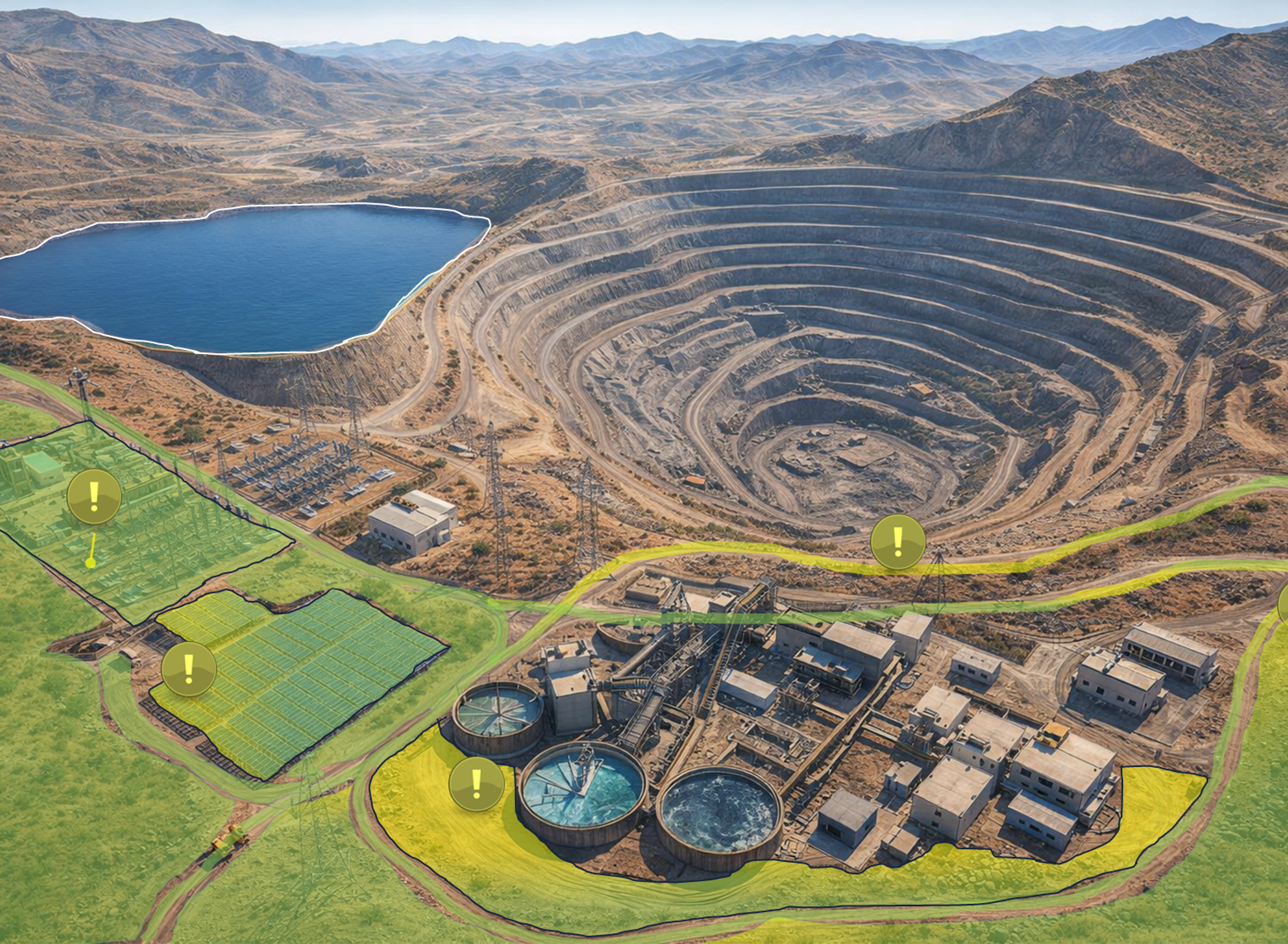
| Diagnosis | Action | Strategic Impact |
|---|---|---|
| Operational roads: no anomalies | Maintain standard maintenance regime | Preventive control without overreaction. |
| Road adjacent to the mine: incipient dust | Irrigation in 3 days | Early dust mitigation. |
| PV: incipient dust / soiling (southeast corner) | Cleaning in 5 days | Recovery of energy efficiency |
| Adjacent ecosystem: Stable; vegetation with incipient water stress adjacent to roads | Coordinated irrigation with dust control | Environmental compliance (EIA) and prevention of progressive degradation, with verifiable evidence. |
| Thickeners: stable operating condition; no thermal anomalies or deformation detected | Continuous monitoring | Operational continuity. |